Researchers pose by an artificial den constructed for test purposes in Utah

Photo: Kt Miller / Polar Bears International

Finding polar bear dens hidden under the snow is no easy matter. Working with partners at Brigham Young University, we’re testing whether synthetic aperture radar, or SAR, could be used to locate, and hence protect, dens. Here, researchers pose by one of the artificial dens constructed for test purposes in Utah.

The Quest for New Den-Detection Technology

By Kt Miller, Senior Manager of Conservation Communications and Outreach

MINS


03 May 2021

Being able to find and map polar bear dens hidden under the snow will help ensure moms and cubs aren't disturbed. Our fieldwork with artificial dens yielded promising results on a new den-detection method, with tests on real den sites to follow.

On a cold day in mid-March, my colleague BJ Kirschhoffer and I pulled into a parking lot at Brigham Young University in Provo, Utah to meet up with a group of graduate students from the engineering and computer science departments. They had agreed to devote their capstone project to helping us further develop and test whether aircraft-mounted synthetic aperture radar (SAR) could be used to find polar bear dens hidden under the snow.

The excitement in the group was palpable. I mean what graduate student wouldn’t be excited about working on a research project involving polar bears? We confirmed the location of our test site and began a drive on winding roads into the mountains southeast of campus. As we drove, the snow began to get deeper and deeper. We soon found ourselves at the top of a small mountain pass with a perfect meadow, scouted earlier by one of the students for our test.

Researchers construct artificial polar bear dens for testing

Photo: Kt Miller / Polar Bears International

The team set to work constructing dens to test.

We gathered our shovels and probes and got to work. Polar bears don’t den in Utah, of course, so, as a team, we dug six artificial dens for testing purposes: three empty snow caves, and three with simulants made from foil that mimicked the size and shape of polar bears.

Polar Bears International staff member BJ Kirschhoffer shown excavating an artificial den for the SAR test

Photo: Kt Miller / Polar Bears International

Polar Bears International staff member BJ Kirschhoffer shown excavating an artificial den for the SAR test.

Because the snow was somewhat shallow, we first piled snow into three large mounds, let the snow set, and then excavated a cave within, ensuring the artificial dens were approximately one meter beneath the snow surface. Afterwards, we dug three additional trenches, laid three foil simulants in the grooves and simply piled snow over the top for a second burial approach that was much quicker to construct.

Below the artificial dens, the team created three trench and bury simulants to test a second,  quicker, burial method.

Photo: Kt Miller / Polar Bears International

Below the artificial dens, the team created three trench and bury simulants to test a second, quicker, burial method.

The day started out snowy and cloudy, but by the afternoon the sun started burning through the clouds. It took the majority of the day to dig the caves and bury the simulants. By then, our arms were sore from digging and our faces weathered from the sun. We departed for town with our tasks accomplished and tired arms.

The next day we got an early start and arrived at the site just after sunrise. Our weather window was narrow, with clouds forecast later in the day. This required us to schedule the SAR flight early to minimize variables and giving us the best chance of capturing successful data. The big question: Would the radar be able to locate the dens?

Just before the SAR plane arrived, we placed a simulant in one of the artificial dens and staged people in the other two. (The three simulants that had been trenched and buried were already in place.) BJ Kirschhoffer, our director of field operations, joined me in sitting on the surface of the snow to show what a surface object might look like to the radar compared with the dens hidden under the snow. BJ took notes and gathered distances with a range finder while the plane flew overhead.

Plane flying overhead

Photo: Kt Miller / Polar Bears International

After what felt like a long time, but was actually less than an hour, we received a radio call that the plane was ready for phase two of the test. We quickly removed all of the simulants (and people) and let the pilots know we were ready for the flyover with no targets in the dens. That way we would have baseline data from empty dens in the same location for comparison. The second pass began while we waited at the top of a nearby hill.

After receiving a radio call confirming that the second pass had been completed, the plane turned back toward the valley. The drone of the engine faded away and silence settled in. We took a few more measurements, carried our gear up the hill, said our farewells, and packed the cars for home, winding down the mountain roads back to the bustle of the valley below.

BJ Kirschhoffer (Polar Bears International) and James Smith (Brigham Young University) took measurements of each den.

Photo: Kt Miller / Polar Bears International

BJ Kirschhoffer (Polar Bears International) and James Smith (Brigham Young University) took measurements of each den.

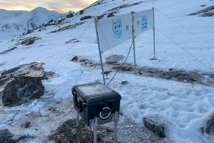
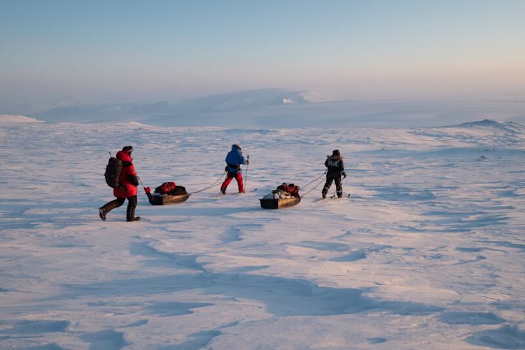
This field effort was the culmination of a year-long capstone project that paired a group of senior engineering and computer science students and their faculty advisors with our team. The capstone team spent their first semester analyzing data from our past pilot SAR efforts in Alaska (also in partnership with Brigham Young University) and conceptualizing the challenges prior to this test.

The results of this pilot effort are very promising, with SAR successfully detecting both empty dens as well as dens with foil simulants and people. We gained enough information to further fine-tune SAR protocols for testing on known polar bear dens in the Arctic next spring. Following discussions with the team, we also plan to collect SAR data on polar bears walking on the surface of snow and sea ice to better understand their radar signature, which will further aid analysis.

If successful in the Arctic on real dens, SAR could be the next tool for den detection across the Arctic, replacing forward-looking infrared (FLIR), which is greatly limited in application by weather conditions like blizzards or fog—a frequent occurrence in the Arctic. Recent FLIR research conducted by our team shows that FLIR flights miss more than half of know polar bear dens in a given area, an unacceptably high rate that puts moms and cubs at grave risk of being disturbed. The high failure rates of FLIR underscore the importance of finding a better way to detect, and hence protect, denning moms and cubs.

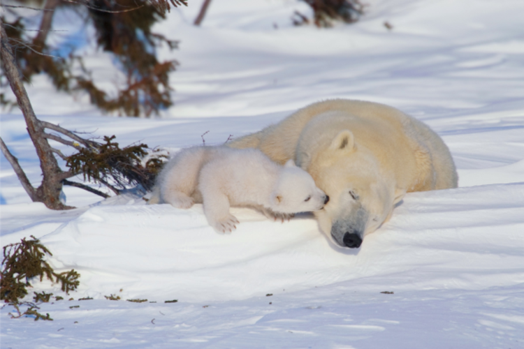
Denning is one of the most vulnerable time periods in a polar bear’s life. Many scientists think of a polar bear den as essentially an extension of the womb. Polar bear cubs are blind and lightly furred when they are born; they need the protection of the den in order to survive until they are big enough to venture out into the cold and onto the sea ice. As climate warming and sea ice loss open up the Arctic to more industry, it is becoming increasingly important to be able to detect and protect critical denning areas, ensuring mother polar bears have a chance to successfully rear the next generation of cubs.

Detecting and protecting dens will be key to long-term conservation efforts, especially in places like Alaska with ongoing industrial activity. SAR may also play a role in detecting polar bears on the sea ice surface, not from an aircraft, but from an earth-orbiting satellite. The ability to detect and count bears on the sea ice surface would be a significant advance in monitoring populations range wide.

We're grateful to our generous donors for funding the first phase of this important research. Special thanks, too to Dr. Tom Smith, professor of biological sciences at Brigham Young University, for organizing this project and for connecting us with the university’s engineering and computer departments; to Dr. David Long, faculty advisor and director of BYU's Center for Remote Sensing; to Evan Zaugg, engineer with ARTEMIS, Inc.; and to the graduate students who conducted the research: Christopher Aniel, James Smith, Katherine Wright, Kyle Evans, Tayler Livingston, Tyler Christiansen.